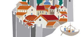

The fortifications
All
that remains of the original Frankish fortifications are two enclosures, one
external and one internal, the donjon and few other traces, as down the
centuries both the Byzantines and the Ottomans constantly adapted them to meet
the needs of war.
New
walls were erected when the settlement was founded some time after 1262,
originally so as to include the nobles’ houses and the despots’ palaces in the
upper city, and later the remaining houses and monasteries in the lower city, also
known as Mesochora. The first Frankish enclosure began to the north-west of the
castle, descended to enclose the central plateau where the palaces were built,
and then ran to the south, above Pandanassa, to the edge of the rock above the
precipice. The second enclosure was probably founded in the 14th century; it
began above Aphentiko and ran below the Cathedral to reach Peribleptos. The
upper and the lower cities were linked to each other via what is now known as the
Monemvasia Gate, and with the outside world via the so-called Anapliou Gate. A
rampart was later built in front of this, creating a broad open space in front
of the main wall. At this point the rampart and wall formed a special stronghold
that effectively controlled the movement of people and goods in and out of the
city.
The
particular location of the monasteries dedicated to the Virgin Mary (Pantanassa
in the eastern leg of the first enclosure, and two others on the edges of the
second) indicate that the organization of the city fortifications provided for
independent fortified points at the edges and the most vulnerable points of the
settlement. It is perhaps no coincidence that the three monasteries were
dedicated to the Virgin, as was Constantinople
herself. The main entrance to Mesochora was known as the Marmara Gate; smaller
gates have come to light or are thought to have existed at particular points in
the settlement, close to monasteries or at the ends of small streets that
originally led to the wall. The rectangular and round wall towers were built
close to each other using strong rubble masonry interspersed with bricks, occasionally
in a decorative mode or as free cloisonne masonry. They secured defence and
remain impressive to the present day.
Glossary (0)
Information Texts (4)
The palaces:
The topography of the hill greatly influenced the spatial
organization of the Pano Chora (Upper
Town) in Mystras. The
despots’ palaces were built on the large natural plateau in the north section,
with a square laid out in front. To the south, the incline allowed for the
construction of what were mainly wide-fronted mansions and small auxiliary
buildings.
The palace complex occupied the edge of the plateau, up
to the brow of the precipice, so as to dominate the city and have the widest
possible view out over the Eurotas valley. The complex included the seat of the
State Administration and accommodation for the despots, the court and the guard.
In front of the palace was a rectangular piazza measuring over half an acre –
unprecedented by imperial city standards, this was probably a conscious
imitation of the squares in late medieval Italian cities, and may well have
been the venue for the renowned annual fair. However, it was not level and did
not have a guaranteed water supply; at some unknown time a small tank named
after a Cantacuzenus was set up in the southwest corner.
The palace complex was not the result of a single
concept, nor was it built as a unified construction project. The L-shaped
ground plan consists of several structures built sequentially from the mid-13th
to the mid-15th century. According to Anastasios Orlandos, who first
carried out restoration work and brought the palaces to the fore, Buildings
A and B in the north wing are those from the Cantacuzenus period of government.
Building A had a large vaulted hall on the ground floor, a wooden roofed upper
floor and a four-storey tower on the west side. The pointed limestone arches in
the ground and upper floor windows were of the type commonly found in western
architecture, and allow us to surmise that the building may have been founded
before the castle was handed over to the Byzantines in 1262. The small domed
Building B was probably auxiliary, since it had underground water rainwater tanks,
a cooking hearth and laundry facilities on the ground floor. Building C in
between A and B must have been built after the mid-4th century; it stood
four-storeys high and had wooden floors and fireplaces in the south-east corner
of the top two floors. Building D is likewise contemporary with the first
period of the Palaeologan administration of Mystras, and was probably the main
living quarters of the despot and his family. It was a two storey building with
rooms on the ground and first floors, and a balcony on the north side ending in
a row of piers with modillions on the top of the parapet. The room layout
changed at least twice, while the balcony pillars were strengthened at a later
time. One interesting feature is a private chapel in a first floor room,
with a small arch in the east corner.
The latest of the buildings is E, a large oblong
structure occupying the west side of the square, possibly built in the first
half of the 15th century. The basement had vaulted storage areas. The slightly
elevated ground floor was divided into eight oblong rooms that housed the guard
or auxiliary staff; each of these had a private entrance, cabinets in the walls
and a hearth at the back. The first floor was a large single room 10.5 metres
wide with a hipped ceiling. The long sides of the hall had large single - light windows
decorated with Western influenced lancet-type stone frames. In the centre of
one long side there was a niche for the despot’s throne; along the long side
overlooking the square there was a wide balcony supported by a row of piers in
front of the ground floor and the basement.
The church of the Virgin Mary Pantanassa:
The Monastery of Pantanassa, which dominates the
eastern edge of the fortified enclosure, was the last church building project
in the city. It was founded in 1428 by the second in command of the Despotate,
protostrator John Frangopoulos, as revealed by the dedicatory verse inscription
in the western dome of the gallery and monograms in various parts
of the church. The walled area extended eastward from the median wall between
the Lower and the Upper City of Mystras. At the lowest, most prominent point,
the Byzantine dignitary funded the construction of a so-called “Mystras type”
church, combining a three nave basilica on the ground floor with a cross-in-square
church on the upper floor. The two-storey building is surrounded by a tall,
slender bell tower and two porticos arranged in an L-shape, though the western one
has not survived. At the same time, numerous decorative elements are tastefully
combined on the building’s faces. The variety of decoration is most apparent on
the east side and the four-storey bell tower. The monument shows strong western
influence and confirms the eclectic character of 15th century architecture
in Mystras. On the inside, apart from the reused sculptures and the 17th-18th
century frescoes on the ground floor, the galleries and the upper building are
covered in excellent 15th century paintings, which echo those in Hodegetria
(Aphentiko) and Peribleptos. As a whole, they are among the most important
creations in the last phase of Palaeologan painting. One of the narthex vaults
has a funerary portrait of the Byzantine ruler Manuel Lascares Chatzikes, who an
inscription records as passing away in 1445. On his head he is wearing a hat
similar to that worn by Emperor John VIII Palaeologus.
The church of Panagia Hodegetria or Aphentiko:
The Church of Panagia
Hodegetria (Our Lady of the Way) or Aphentiko is the new catholicon of
Vrontochi Monastery, abutting the massive walls in the north-western part of
the lower city of Mystras.
It was built in around 1310 by an energetic abbot named Pachomius. According to
two chysobulls painted in the southwest chapel, he managed to
secure imperial grants of considerable lands in the Peloponnese
and a lifetime appointment as head of the monastery.Hodegetria is a large,
imposing two-storey building that shows architectural innovation: while the
upper part is a five-domed cross-in-square church with a narthex
and galleries, the ground floor is a basilica divided into three
naves by arched colonnades. This church type, known as the "Mystras
mixed type", was used for other monuments in the vicinity (Pantanassa,
Agios Demetrios). The nave is built of roughly hewn stones with occasional rows
of brick, and was probably originally plastered. The east side of the building
retains its original form and exhibits stylistic elements similar to those of
contemporary monuments in Constantinople. The
sanctuary apse and pastophoria are divided into zones with windows and
blind (bricked up) arches. In the upper zone, low, flat niches with double
brick arches complete the exterior decoration. The church was surrounded by porches
arranged in a pi-shape, covered with hemispherical domes. The south
porch was converted into a burial chapel in the 14th century, when the
openings in the ground floor were walled up and turned into burial niches. Two
additional chapels were created at either end of the narthex, and a
further two at ground level in the north porch. The three-storey bell
tower to the south of the west portico is built of cloisonné masonry. On
the outside, the upper level is separated from the ground floor by a marble cornice,
and has triple-light windows adorned with brick arches. Higher up, the tower’s
exterior appearance is complemented by shallow blind niches.The interior decoration
was sumptuous, combining sculpture decoration, marble revetments and wall
paintings. Only a few pieces of the sculpture decoration and rare revetments
have survived. The wall paintings date to different periods; some fragments are
visible in the nave, along with better preserved sections in the chapels.
In the main church, the frescoes dating to the 1410’s are obviously the work of
painters from Constantinople. They depict an
extensive Christological cycle, martyrs and saints in the side aisles, prelates
and deacons in the sanctuary, and patriarchs, prophets and apostles in the
galleries. The compositions in the chapels reveal the personality of Pachomius,
the founder. In the so-called chrysobull chapel in the south-west, four angels are
holding a mandorla around a now lost depiction of Christ, from which
beams of light descend by divine hand, holding the chrysobulls of Emperors
Andronicus II Palaeologus and Michael IX. Pachomius is buried in the northwest chapel,
where successive rows of saints’ choruses are depicted praying to Christ; Pachomius
appears on an arcosolium on the western side, offering a model of the church to
Our Lady. On the north side is the tomb of Despot Theodore I Palaeologus
(1384-1407). According to his burial mural, he became a monk and took the name
Theodoretos.The southeast chapel is probably dedicated to the Three Hierarchs. The
decoration in it is later, and depicts the vision of Agios Ioannis Euchaita
(St. John, Bishop of Euchaita), which when interpreted led to the establishment
of a joint feast day for Basil the Great, Gregory the Theologian and St. John
Chrysostom. The frescoes can be dated to 1366 on the basis of the monogram
above the chapel entrance, representing Cyprianus, Episcopal Vicar and Abbot.
Finally, the frescoes in the south portico date to later in the 14th century;
the portico served as a burial place for rulers, as is evidenced by scenes in
the dome, burial paintings of a noble named Kaniotis and his wife in the west
arcosolium, and of another officer on the northern wall.Under Ottoman rule the
church served as a mosque before being abandoned. In the early 19th century,
columns were removed from the colonnade to be used elsewhere, while the
central part of the dome and galleries collapsed.
The city:
Constantinople, the capital city of the Byzantine
Empire, was built on the site of the ancient Greek colony of Byzantium, on the
triangular peninsula formed by the Golden Horn,
the Bosporus and the Sea
of Marmara. This was an excellent location that controlled trade
routes linking the Aegean to the Black Sea. Emperor Constantine founded Constantinople
in 330 AD as a city to rival Rome
in splendour, wealth and power. The city grew fast, leading to problems of
space and facilities, so Theodosius I extended it to the west by building new
strong walls that protected Constantinople
until the end of the Byzantine Empire.
The
city was laid out after Rome.
A main road, the Mese Odos, linked the palace to the Golden
Gate. On this road was the Forum, a circular plaza with a statue
of Constantine
mounted on a column, surrounded by public buildings. Theodosius I and Arcadius later
built more forums decorated with their own statues.
Following
the Nika riots in the 6th century, Justinian adorned Constantinople
with magnificent edifices, palaces, baths and public buildings. This time also
saw the construction of Agia Sophia (the Holy Wisdom), the church which served
as the seat of the Ecumenical Patriarchate throughout the Byzantine period.
During
the 7th and 8th centuries Constantinople faced
major problems that threw it into disarray: attacks by the Avars (a siege in
674) and Arabs (attacks in 674 and 717-718); natural disasters (a powerful,
destructive earthquake in 740); and epidemics (plague in 747). Limited building
activity resumed in the 8th and 9th century, mainly concentrated on
strengthening the city's fortifications.
With
the recovery of the Byzantine Empire from the
9th to the 11th century, Constantinople became
the most populated city in Christendom; the majority of inhabitants were
Greek-speaking, but many other ethnic groups lived alongside them, such as
Jews, Armenians, Russians, Italians merchants, Arabs and mercenaries from Western Europe and Scandinavia. Many public, private and church-owned buildings were erected at the time, with
an emphasis on establishing charitable institutions such as hospitals, nursing
homes, orphanages and schools. Higher education flourished, thanks to the care
of the state and the emergence of important scholars. This renaissance lasted
until the mid-11th century, when economic problems due to poor management set
in, compounded by the adverse outcome of imperial operations beyond the borders.
The
Crusaders left Constantinople entirely
unscathed when first passing through, but in the Fourth Crusade of 1204 the
Franks conquered and ransacked the city, slaughtering those inhabitants they
did not take prisoner or drive out. In 1261 the city was retaken by Michael
VIII Palaeologus, who rebuilt most of the monuments and the walls but proved
unable to restore the city to its former splendour and glory. Enfeebled as it
was, the empire was incapable of checking the advance of the Ottomans, and in
1453 Constantinople finally fell into their
hands.
The fall signalled the end of the empire. Nevertheless, the Byzantine intellectual
tradition remained significant, as many scholars settled in the Venetian dominions
of Crete and the Peloponnese,
as well as in European countries, conveying Greek learning to the West.
Bibliography (5)
1. Bon A., La Morée franque. Recherches historiques, topographiques et archéologiques sur la principauté d''Achaïe, 1205-1430, Paris, 1969
2. Χατζηδάκης Μ., Μυστράς. Η μεσαιωνική πολιτεία και το κάστρο, Athens, 1987
3. Η Πολιτεία του Μυστρά, Υπουργείο Πολιτισμού, Athens, 2001
4. Αχειμάστου - Ποταμιάνου, Μυρτάλη, Μυστράς. Ιστορικος και αρχαιολογικός οδηγός, Athens, 2003
5. Runciman St., Mistra, Byzantine Capital of the Peloponnese, Λονδίνο, 1980
Comments (0)